
Small Area Shapefiles
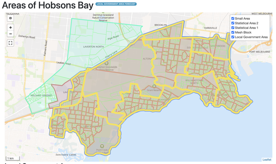
Areas of Hobsons Bay (small areas highlighted in yellow)
When we create your small area forecasts, you, the client, determine the boundaries of your small areas.
If you want to, you can send us your small area boundaries as a shapefile. Here's what we need this shapefile to look like.
Shapefile Requirements
For our system to process shapefiles containing small areas, these shapefiles need to meet a certain standard outlined below.
💡 Tip: We recommend that you download your existing small area shapefile from your forecast, which already meets this standard, and change its boundaries, as opposed to starting your small area shapefile from scratch.
💡 Tip: You can meet our standard with any GIS tool. We recommend QGIS.
This is our standard for small area shapefiles:
- The CRS needs to be GDA2020 (SRID: 7844).
- All small areas in this shapefile need to fully tessellating your LGA. They cannot extend beyond the boundaries of your LGA, nor can they intersect with each other.
- The shapefile can only have a single layer.
- The shapefile needs to be archived into a single ZIP file. The ZIP's filename needs to have the phrase SA in it, such as Hobsons_Bay_SA.zip.
- Each small area in the shapefile must have a unique name and code for each small area in its attribute table. The code is an integer ranging from 1 to the number of small areas.
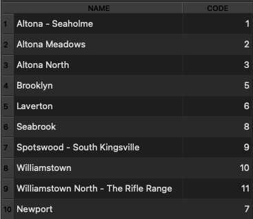
Attribute table for a small area shapefile, with a name and code for each small area
I have a new shapefile! Now what?
Once you have your new shapefile, send it to us. We check it, correct it if necessary, and update your forecast with it. You should hear back from us with your updated forecast within a few hours or days.